
Interpretation Results
Theoretical aspects
Various visualisations of the ALS data (combination of hillshade and slope, local relief model, positive and negative openness) were loaded into a GIS system and used as a basis for mapping. Archaeological features were drawn as polygons and a table attached, storing information on feature-interpretation, relief of feature, name of interpreting person, and date of interpretation. While earthworks, buildings, walls, field-systems, terraces and pathways are often obvious, smaller structures are less so. On basis of the DTM it is often impossible to distinguish natural and recent features from archaeologically relevant structures. Therefore, field visits are a necessary component of any detailed interpretation. Using a GPS, mapped features can be visited and identified. During site visits to St Anna, additional information was gathered which otherwise could not be derived from the ALS data, including construction materials (stone type and mortar), mason’s marks and artefacts which helped advance interpretation and provided dating evidence. In the field, small DTM-features could be identified as dense bushes, fallen trees, stones, tree stumps and the like. This information, as well as the general appearance of earthwork structures was documented on photographs. The georeferenced photographs (the camera was connected to a GPS) were imported to ArcGIS, supporting the production of an interpretation key, which was used to refine interpretation and which will be a valuable basis for future projects.
Description of the physical remains
Altogether, more than 1.300 individual archaeological features could be identified and mapped. They reveal a complex archaeological landscape around both the monastery and the ruined castle of Scharfeneck, consisting of, a prehistoric hillfort with attached burial ground, field systems, a network of paths and hollow-ways, the monastery complex with seven ermite’s cells, fish ponds, and a surrounding wall, as well as quarry sites for limestone extraction, lime kilns etc.
Description of the interpretation results
Most side valleys in the Leithagebirge are gorges with a v-shaped cross-section, but around the friary complex the valley widens from east to west along the Arbach stream. This little valley is flanked by two ridges, which rise about 50 m above the Arbach. The little valley basin is today occupied by the remains of the St. Anna in der Wüste friary complex, abandoned in 1783, which lies at the foot of the so-called Schlossberg (Castle Hill). Schlossberg is the site of a prehistoric hilltop settlement, repeatedly occupied between the Later Neolithic and the Hallstatt periods. A group of low-relief, presumably Early Iron Age, round barrows is spread across the north-eastern side of a small hill some 400 m south of the earthwork.
Scharfeneck Castle was erected within the hillfort in the late 14th century. The locality has since the Middle Ages been further shaped by the quarrying of limestone for building stone and the manufacture of mortar. An aerial photograph from June 2003 shows the thickly-wooded character of the area, comprising mostly mixed oak and beech, with thick undergrowth in some areas. The immediate vicinity of the friary is largely free of tree cover.
The relatively late foundation of a noble residence – the first reference to a noble family there is 1383, while the castle is first mentioned in 1417 – can probably be explained byits location on the border of the Duchy of Austria and the Kingdom of Hungary: The political affiliation of the place changed several times over the course of the centuries. The castle was abandoned in the second half of the 16th century, after lightning had partially destroyed the keep in 1555. In 1683 the ruin served the local population as a place of refuge from Turkish troops, who laid siege to Vienna and laid waste large parts of eastern Austria as the Ottoman Empire expanded eastwards.
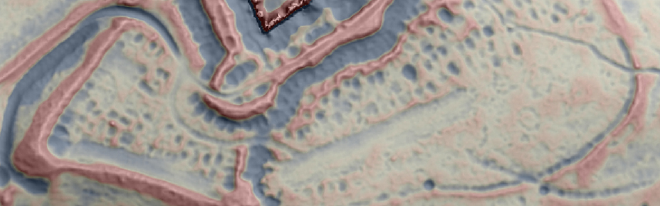
Following the desertion of the castle in the 16th century, a hermitage of the Discalced Carmelites namedSt Anna in der Wüste was founded in 1644 on the initiative of the Imperial widow Eleonora. The remains of the friary, arranged like a Carthusian complex around a church are clearly visible in the central part of the valley floor. The shaded plan of the terrain model shows further details. Individual hermitage buildings, most of which survive only as foundations, can be clearly seen in the plan.
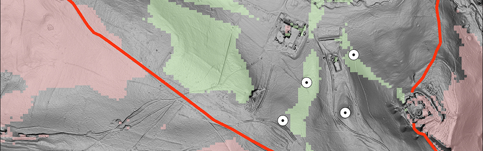
Among the known structures the remains of limestone quarrying and processing are most common, unsurprising since the easily workable Leitha limestone was used for dressed stone and mouldings over a wide region from at least the later Middle Ages onwards. Numerous quarries and lime kilns of varying size are scattered over the entire area.Important insights about the spatial concept behind the friary complex can be gained from a bird’s eye view engraving of the friary by J. Martin Lerch. It is clearly a view of the physical space, but on closer inspection there are distinct differences in the form and position of individual structures compared to the ALS-based digital terrain model (DTM). In contrast to modern mapping, the engraving cannot be seen as an exact geometric representation of the physical space, but rather reflects the cognitive space of the artist or his patron. The central picture of the engraving shows the friary, as restored after the Turkish war of 1683, as part of an idealized landscape encircled by orchards and surrounded by woods, thus creating a sense of ‘wilderness’ as a place of retreat. The idealized course of the enclosing wall is particularly apparent when compared to the terrain model. The actual course of the wall only bulges out significantly around the burial mounds south of the castle, but the engraving shows two symmetric arcs, which together with the hollow of the Arbach valley form the shape of a heart. The heart image is repeated in the middle of the picture in the shape the meadows surrounding the friary. It is highly likely that the Sacred Heart motif is in this way being written into an imagined monastic landscape of ‘wilderness’. This motif drew on the heart metaphor employed in the New Testament and by Augustine, and was particularly popular during the Counter-reformation, especially after the introduction of the Sacred Heart holiday in 1672.
Further investigations on the course of the wall showed that there is an obvious discrepancy between the course of the wall in reality and its portrayal in the engraving by Martin Lerch. Shows that the wall is only vaguely heart-shaped. An explanation emerge dusing visibility analysis. I could be demonstrated that a visibility map with a target height of 1.5 m measured from the top of the friary’s church tower reproduced the course of the wall almost exactly. Even the protuberance deviating from the potential heart shape seems explainable, as this section is also part of the area from which the top of the friary’s church tower can be seen. The course of the wall can thus be explained by the desire to be fully isolated form the surrounding world, a result which fits the written information about the preferences of the Carmelites.