

Results
Due to the previous research and assumption that the Roman settlement and associated cemeteries are well spatially defined, no surprises were expected. The expectations had been limited to the detection and mapping of buildings or constructions for agricultural purpose located away from the main residential buildings, as well as to roads and paths connecting the settlement with its nearest neighbors. The discovery of entirely new “sites” was a surprise both in qualitative and quantitative regard.
The large settlement is divided into two living and working areas, which were occupied from the 2nd until the 5th century AD as the results from systematic field walking are indicating. Although they were already known in the 90's, it was only now that new and completely unknown settlement parts were detected. Two main living houses – one of them for the first time recorded – indicate two main living areas, each of them including several other subsidiary stone buildings, which are irregularly scattered over the terrain. Size and shape of the northern farm were defined by a ditch system, serving not only as an enclosure but also as a division of the estate into several parts; the southern farm was enclosed by a rectangular wall.
Aside from several stone buildings some 80 grubenhäuser have been documented in the area. Only a quarter of those structures are in close proximity to the stone buildings, which can also indicate a possible overlapping of sites dating to two different periods. Actually, there exists also some evidence of a Late Iron Age settlement derived only from the results of field surveys. The Late Iron Age material was found only next to the stone buildings of the northern farm, while the Roman pottery distribution corresponds with the distribution of the pit houses. Moreover, a small excavation in 2001 has detected only Roman settlement features of the 2nd and 3rd century AD. Perhaps it can be therefore concluded that most of the grubenhäuser are to date u in the Roman times.
The research up to 2002 has verified two graveyards related to the settlement. They were situated approximately 200 - 300 m east (Halbturn I) and west (Halbturn II) of the settlement. Both graveyards were located on a higher level than the settlement. Good visibility of the graves, if coming from afar, may have played a role in the remembrance of the dead. Halbturn I was completely excavated (300 cremation and inhumation burials) and provides us today with important information about chronology, rituals, social structure, living standards and habits. One of the highlights was the discovery of the Jewish amulet in a child's grave. The graveyard Halbturn II was up to now only known from a small-scale rescue excavation conducted in the 1960s, revealing a burial from the 3rd century. In 2012 we could document this graveyard for the first time: it is a small cremation cemetery from the 2nd/3rd century AD, consisting of several round and square grave enclosures. Poor preservation conditions have here perhaps veiled the original size of the cemetery. New measurements have also led in the NE of the settlement to the discovery of a third cremation graveyard with grave gardens, very similar to the other two.
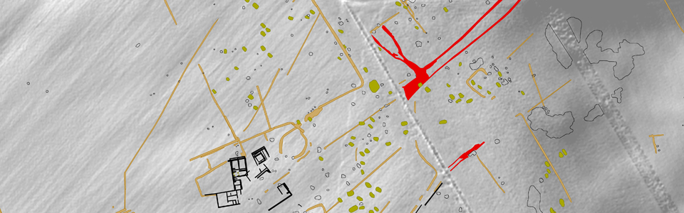
The new large-scale archaeological prospection surveys have confirmed a wide-ranging and multi-phased ditch system located between the settlement area and the cemeteries. The field system can be dated into the Roman times because some of its sections have been verified during the excavation of graveyard Halbturn I, since parts of the ditch system were embedded into the graveyard area. The purpose of the ditch system was probably not merely to parcel the land – the construction of the ditches would have been too large for this purpose alone – but may have additionally been used for water drainage, for cattle enclosures or something similar. The single plots almost all have a rectangular shape in different sizes. The parcelling of land did not just comprise field surfaces, because smaller plots stretched into the settlement area as well. Interestingly, standard Roman measures could not be derived from the mapped field boundaries; it seems that instead of the Roman actus (35.52 x 35.52 m) a width of 25 m played a role. Incorporated into a ditch system we can find remains of the road system.
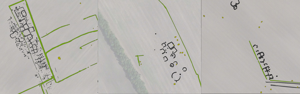
South of the modern road a completely new settlement features were detected: extending over a length of about 450 m, numerous features of enclosure type, of which the majority does not have perfect rectangular shape, were found. In addition, remains of at least four wooden buildings were documented as well as a one more graveyard, with apparently only inhumation burials. It is quite possible to interpret is as another Roman graveyard (4th and 5th century AD), but since the area south of the modern road has not yet been fully surveyed and investigated, the dating is not provided with security. The same can be said about the settlement features nearby. The ditch system differs fundamentally from the familiar Roman plots but it fits geographically, with no overlap with Roman structures, into the relief. A small-scale unsystematic filed walking done in 2012 has revealed only Roman material. At the same time it must be said, that Middle and Late Bronze Age graves are supposed very near (200-600 m), which may possibly indicate the dating of this settlement features in to the prehistoric times.